
When I initially booked our visit to Morro Bay, one of my goals was to use it as a jumping off point to drive a particularly scenic portion of the Pacific Coast Highway. The PCH is a 1675 mile coastal road that begins in Washington state and ends in Southern California. The section we were interested in, between San Luis Obispo and Carmel, includes the oft photographed Big Sur and is designated a National Scenic Byway. Driving the PCH has been a bucket list item for years and our visit to Morro Bay seemed like the perfect opportunity to make it happen.
But, in January, just a couple days after I booked our stay, this happened:


A massive rainstorm that dumped 7+ inches of rain in an area ravaged by wildfires last year resulted in a mudslide that took out over 150 feet of the road.
These landslides have been a regular occurrence on the PCH for decades, but they are becoming more frequent and more destructive as climate change continues its assault on the environment. (As I understand it, the state closes the road when big storms are forecast in order to keep drivers from getting killed in a landslide…which is very nice of them.)
As you can imagine, fixing a problem like this takes a lot of time, money, and manpower. Prior landslides had resulted in road closures that extended between 8 and 14 months. Fortunately, the state estimated this repair wouldn’t take quite that long, but it would still be too late for us. We would be in Morro Bay for the month of April and CalTrans, the state’s department of transportation, was estimating they would have the road re-opened by the Summer.
Dammit.
But, all was not lost. Within a couple weeks, CalTrans created turnarounds on the north and south sides of the damage, allowing tourists to drive most of the route either from the north or south.
We figured we’d take a trip from the south and just see what we could see before the turn around.
However, before we could even do that, the good folks at CalTrans announced they were moving the schedule up! They announced they would actually be done and have the road re-opened by April 30…. which was the day I was scheduled to get my second vaccination and the day before we left the area.
Foiled again!
BUT…a funny thing happened the night before we planned to drive up the southern portion. I was on google maps figuring out where we should stop and I noticed the road was completely open!
Turns out, CalTrans was able to finish their work even ahead of their accelerated schedule!
How could this be? How could this go from a 6 or 7 month project to a 3.5 month project to a 3 month project?? My guess is, it went something like this:
Frank: Hey boss… Ya know how the plan calls for each section of bracing to have 12 bolts? Well, I’ve just been using 3 bolts and it seems to be holding up fine! Whaddaya think?
Boss: Tomato-Tomahto, Frank. Tomato-tomahto.
And with that, we were off!
(PS: Thank you, CalTrans District 5 – Y’all rock!!)
The Pacific Coast Highway
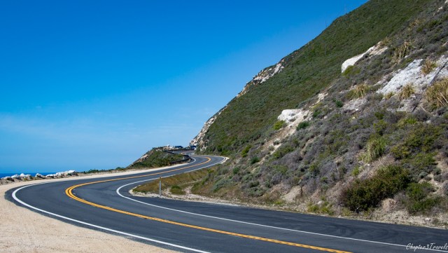
The portion of the PCH we traveled, between Morro Bay and Carmel, is about 110 miles long. There are times the road leaves the coast and goes a bit inland, but the vast majority of it hugs the cliffs overlooking the Pacific. For RVers, we would strongly suggest leaving your rig at whatever campground you’re staying at and driving your car. While oversized vehicles are not prohibited on this stretch of the PCH, and plenty of people do it, I can promise you, this guy was not having fun…

In addition to the whole ‘trying to not crash into someone while driving in the wrong lane” thing, many of the overlooks and vistas have limited space for parking, so driving the PCH in a big RV would result in a whole lot of stress with very few rewards.
If, on the other hand, you are in a smaller RV or you are planning to tent camp, there are some state park campgrounds along the way that looked positively dreamy.
No matter what your plans, be aware there’s no cell coverage, very few services, and no street lights, so plan ahead, come well prepared, and try to be off this stretch of roadway before it’s completely dark.
Northbound
Heading north from Morro Bay, there are several pretty, sandy beaches and look outs, but the first must-see stop is the elephant seals rookery in San Simeon. While there are always seals on the beaches in this location, there are several particularly popular times: winter, when males arrive and try to stake their claims on pupping areas, early Spring when pregnant females arrive to give birth and then mate again, and late Spring, when seals return to molt. We were there when there were young pups still on the beach and some of the older ones were in the process of molting.
As we continued our trek north, the road started twisting and turning and gaining elevation over the sea. The landscape was rocky with little vegetation, but by looking far enough into the distance, we could see the colors of the water start to change.

As we drove the next section, we were blown away by just how turquoise the ocean was:

We also noticed hundreds of seals, visible here as little black marks in the water, swimming away from the coastline. The bridge is the Big Creek Bridge which spans the Big Creek River.
Somewhere in this area, we came around a corner and saw an incredible floral display on both sides of the road. On the right, was this little island carpeted with bright pink flowers and on the left, creating a border between the road and the ocean, were hundreds of California’s state flower, the poppy:


I’m still not sure what this area was or who maintains it (you can see there’s an empty sign post standing among the pink flowers), but it was strikingly beautiful and pretty much everyone driving the PCH stopped to admire the scene.
Soon, we got to our first major stop: McWay Falls, which is part of Julia Pfeiffer Burns State Park. There’s a small parking area on the east side of the PCH which also provides access to several inland trails, however, the belle of the ball is accessed by a quarter mile trail that goes under the highway, and leads to an overlook:
 The viewing area looks down on a rare beachside waterfall next to the jewel colored sea:

Unfortunately, the overlook beyond this point was closed for construction, so this was as far as we could get. Visitors are not permitted on the beach at all.
Continuing on, we pulled over to take in this view from Sea Otter Viewpoint. Though we didn’t see any otters, we did notice this impressive cliff side home with its rather enviable views (unless there’s a mudslide in which case, it’s not so enviable anymore.)

Hurricane Point & Bixby Bridge
Bixby Bridge is one of the most iconic landmarks on the PCH. If you’re coming northbound, definitely stop at Hurricane Point to take in this epic view. If you look closely, you can see the bridge out in the distance.

Once you cross the bridge itself, there are small parking lots on both sides of the road where you can admire the bridge, from the back:

and the front:

This part of the PCH is Big Sur which boasts all the quintessential elements of this spectacular byway. The scenery is dramatic with plunging cliffs, crashing waves, rolling green hills, and stands of remarkably colorful wildflowers.


Garrapata State Park
Eventually, we stopped at Garrapata State Park and walked the Bluff Trail. Here, the rocky coastline is carpeted in greenery. The Bluff Trail also includes natural stairs carved into the cliffs as well as a wooden bridge over a creek. The trail’s designer did a fantastic job of making the whole trail blend into the cliffs without standing out.
Point Lobos State Reserve
The endpoint of our trek north was Point Lobos State Natural Reserve. Here, we meandered sections of several walking trails, taking note of the beautiful wildflowers and the variety of tree and plant life:


Down on the beach, we gawked at the swirling tides and listened to the thundering waves:
If we’d had more time, we would have loved to walk the entire 7 mile loop trail that circumnavigates the park, but we knew we needed to head home.
Southbound
Once we turned south, the views only got better as the sun dropped in the sky:

On our way back we stopped at a different section of Garrapata State Park to find the Calla Lily Valley. Yep, that is a thing that exists on this planet – an entire valley, just a couple hundred yards from the Pacific Ocean, bursting with striking white calla lilies.
Seriously, California: now you’re just showing off.


As you can see, our visit was at the very end of their season and the flowers were starting to die, but it was still quite a sight.
We headed further south, stopping briefly to take in the view of Bixby Bridge from Notley’s Landing:

and stopped once more at Hurricane Point to take a couple sunset photos, one of which is the featured image at the top of this post. If you look really closely at that photo, you can see a bunch of cows in the center of the grassy area. I guess they get dinner and a view every evening.
Nearby, we spotted this incredible house, perched on the very top of a cliff, surrounded by trees, and enclosed primarily in glass.

Talk about getting away from it all…
Continuing south, we watched the sun set, took a few last snaps, and headed for home.

To say the Pacific Coast Highway lived up to expectations would be an understatement. This was an absolute standout travel day and one of the best experiences we’ve had on the road. We couldn’t see everything (Hearst Castle was closed, we didn’t have time to stop for lunch at the oft-recommended Nepenthe Restaurant, etc.) but over the course of about 10 hours, we saw an unbelievable amount of stunning scenery.
Bonus Awesomeness
Montana de Oro State Park is located on the coast just south of Morro Bay. I didn’t include it in my last post because it’s not a town, and it’s not actually part of the PCH, but it’s a beautiful park worth a visit if you find yourself near Morro Bay. The best way to experience it is to walk the 4 mile bluff trail that tracks the coastline. Other trails lead up into the hills and offer commanding views over the park and ocean if you’re looking for a bigger challenge.
This section of coastline is just as striking as Big Sur, and if you visit during Spring, you’ll enjoy loads of colorful wildflowers in addition to the sensational ocean views.
If you find yourself in the area, don’t miss it!
Next Up…
Yosemite National Park, Sequoia National Park, and exploring U.S. 395.
__________________________________________________________________
Where we stayed: Cypress Morro RV Park, Morro Bay, California
PCH is on our bucket list!! I also want to run the Big Sur marathon. Seriously, it’s GOT to be stunning. Love the pics of the elephant seals, the captions made me laugh out loud!! I’ve never seen calla lilies in their natural habitat. How beautiful! One of my mom’s favorite flowers ?. Glad you were able to take this route!!
I honestly can’t imagine a more scenic route for a marathon… or a more hilly one. But it would be gorgeous, no doubt! There are also some incredible golf courses north of there…plus wine. Would make for a perfect vacation trip for you guys!
OMG! What a fabulous tribute to the Big Sur and the Central Coast. Your words and photos could/should be in the next Visit California advertisement. It is a beautiful area, I’m gald the weather cooperated and you were able to bring it to life.
Thanks Jeff! We were so thankful that the weather cooperated when the road finally opened. As you are no doubt aware, it can get real touch and go up there. We felt very fortunate to have it all work out at just the right time. Your state is simply stunning!
Oh God, your post brought back such great memories of our 2016 USA road trip…. complete with the day the “poo pipe” housing (which seemed to be made of various bits of botched-together drain pipe) suddenly dropped off the bottom of our Cruise America rental in torrential rain on the PCH.
Luckily, Mark managed to swiftly pull into a handy viewpoint, run out into the road and grab everything before it got run over by oncoming traffic (which was thankfully sparse given the weather), then spent an hour crawling around under the van refixing the shoddy construction using the cable ties he goes nowhere without? Ah, the luxuries of motorhome travel!
O.M.G…. that is horrifying! And ya know, I watch a couple youtube channels about RV travel and one of those folks just had a nightmare involving the black tank on a rental… Seems to be a theme this week or something. Ugh… Glad it was raining, and glad y’all had zip ties! Who knew?? 🙂
Beautiful! Just beautiful! I’m happy you enjoyed your tour on PCH. 🙂
Thanks Tami! It was an awesome day and we loved it!
Okay, my first thought is how in the hell did they fix that section of road?? But I’m so glad they did, and in time for your epic day trip. This is a fabulous guide to one of the most beautiful scenic drives in this country. Really, you should be getting paid for this.
You stopped at some of our favorite places, including Point Lobos and the elephant seal rookery, and you’ve added in a couple more that we definitely need to see. Oh, and I agree with you about Montana de Oro…it’s just as beautiful as Big Sur and one of our favorite spots on the Central Coast. Stop it, okay? I don’t want to be missing the west coast right now.
Thank you, Laurel. Your blog and advice were instrumental in helping us figure out where to go and what to do for this whole chunk of time, so thank you again. It was really the perfect place to go this Spring and we loved it.
I have no idea how they completed that road work so quickly. I guess part of it is they have lots of practice now because it keeps happening. I just hope this isn’t another terrible fire season up there. It is such an incredible area. Just gorgeous!
Grew up in Sacramento and driving the coast is only second to Yosemite. Over the years I have been on the entire stretch from Olympic National Park to San Diego…my favorite part is definitely from Santa Cruz to Santa Barbara.
Man, I am jealous. I would love to drive the entire thing! We still haven’t been to Olympic NP, but did see a bunch of the Oregon coast and it was gorgeous. We’d love to drive more of it at some point – including north of Carmel and south of Morro Bay. It truly is a spectacular area.
You made my day, seriously. I used to live in the Santa Cruz area (12 years!) and one of the big signs of spring were “the purples” as the locals call them, those “pink” ice plants that cover the hillsides of Pacific Grove, Asilomar, and south. It’s a huge weekend thing to park and walk along the streets lined with purples. And I didn’t realize how much I missed the purples until I saw your photo.
And those cows in the first picture? In another lifetime, I ran the Big Sur marathon (using the word “run” kinda loosely) and at one point, the cows got spooked and started running. Faster than me. That was a big sad, but then someone said “They aren’t doing 26 miles, so take that, you running cows.” I still laugh when I see a cow along that stretch.
Seriously, though, you did a wonderful job of catching all the reasons that stretch of the CA coast is one of my happy places. From the words to the photos, you nailed it. I’m totally homesick right now 🙂
Oh man, that’s so cool. Not the part about me making you sad, of course, but the rest of it. 🙂
How interesting about “the purples”! They were an absolute show stopper – for us and everyone else. I remember driving around the corner and saying “Wow… WOW!!” and just pulling over – along with everyone else. They are just beautiful and we hadn’t seen them anywhere else.
As for the cows… I mean, not only were they not running 26 miles but they were probably gonna end up being a burger at some point, so I think you won on either count. 🙂
And another place we’ve never seen. This is a MUST DO for us next Spring … if there’s anything left after the fires and landslides. Your photos are top-notch – obviously you were in travel nirvana.
Thanks for showing us how it’s done on the Central Coast.
Carmen @ LIB
Hey Carmen,
You guys would absolutely love this area! And there are some gorgeous campgrounds along the way that you would most definitely fit into and take full advantage of. I, too, hope fire season isn’t too bad this year, but I am not super optimistic. It has been dry, dry, dry. Ugh… Hope you’re enjoying the east coast!
With all that beautiful scenery it is a wonder how people are not driving off the cliffs everyday just gawking at the coast!
Who knows? They might be!! I wouldn’t want to drive it after dark, that’s for sure.
How many memory cards did you have to bust out for this? Did your finger get sore from depressing the shutter button?
What an action packed day you had, not sure we’ll ever see that so very happy to enjoy your wonderful pics. Wow!
LOL. Thanks TBG. Yeah, this was one of those days where I came home and said to Kevin “WHY did I take so many pictures??” It’s easy to keep clicking away. The sorting and the editing take a lot longer!
Great photos and great job for capturing the essence of the California Coast! Doesn’t that reminds you also of the Cabot Trail?
Thanks to your spectacular photos, you are making me a bit “homesick” of our former home state 🙁
Yes! You are completely right about the Cabot Trail. I didn’t think about that, but there are many similarities. We really enjoy these coastal drives. The scenery is just wonderful. And fortunately for you, you’re not THAT far from you’re old home. We heard about all the “Zonies” coming over to visit quite often when we were in San Diego. 🙂
Thanks for driving us down that iconic road! So happy to see that it all fit into your plans after seeming like it aggravatingly wouldn’t. As TBG said, it’s one we may never get to, so virtually traveling with you was the next best thing. I, too, don’t like to think about how they fixed that road so quickly — those cliffside roads scare the bejeebus out of me under any circumstances. The blankets of wildflowers are breathtaking, and the piles of seals are just adorably squishy!
We felt very very fortunate to have this road open when it did and we were very happy it lived up to the hype. I didn’t even know the elephant seals rookery was a thing until I started looking at the road more closely on Google. It really is full of surprises and gave us an unforgettable day on the road.
Such a gorgeous drive!!! One of my favorites as it reminds me of growing up in South Africa and the coastal scenery there. The wild flowers are an added plus that’s for sure. Gorgeous photos always a winner.
This time we were pressed for time do we take the inland road and I did miss the seals and the dramatic seascapes!
Peta
Thanks Peta! I’ve only seen pictures of the South African coast and totally agree – it’s spectacularly beautiful in much the same way as the California coast. I hope you get to explore it at some point. I have no doubt you’ll enjoy it very much.
Oh my goodness, beautiful photos and scenery! Glad things worked out and you were still able to see some things here.
Thanks Diana! We felt very fortunate to have the roadwork finish just in time for us to be able to take our trip. Sometimes our timing is complete crap, but other times, it really works out. 🙂
Wow, one of your best experiences yet – that’s quite a compliment! Of course your photos make it easy to understand why this ranks so high on your list. I’m surprised it wasn’t more crowded, or maybe you just artfully cropped the other people out of your shots. California sure does have plenty of stunning scenery… along with, unfortunately, high demand and high prices. I’m so glad that you were able to check off this bucket list item thanks to unexpectedly efficient road work. Thanks for taking us along for the ride!
Thanks, Shannon. I was a bit surprised by the lack of crowds as well, but I really think it was because no one knew the road was open. I only found out by chance. Additionally, we were there at the very beginning of the busy season. During our month in Morro Bay, we noticed plenty of visitors on the weekends, but during the week, it was always quiet. I assume it’s much more crowded now, but Spring was a great time to visit.
The photos are stunning and your description has made me move this up on my places-to-go-list! One of the positives of COVID (if any exist) is that construction projects are moving ahead of schedule due to less people on the road (commute) and an influx of workers who needed to find work. At least that’s what’s happening over here. 🙂
Thanks, Shelby! It was really beautiful and I bet you guys would love it. Hell, the girls would LOVE all the wildlife all along the coast! You could really make a fun family trip out of it.
And I didn’t think about the whole Covid thing, but that totally makes sense. It’s been a good time to get projects done while folks are off the roads. Too bad everyone is now running into shortages of lumber and other supplies. Hopefully things will improve with that soon.
You have seen some pretty spectacular places, so to move this up to the top of your list is impressive. It would take me forever to drive the PCH, I’d never get to do any of the driving because I’d be too busy taking pictures! Love the seals!! How lucky you were to be there for all the wildflowers. I’ve never thought about where calla lilies grow naturally, it must have been quite a sight.
I think I consider some of these travel days standouts because of factors beyond the place itself. Ya know when you’re somewhere beautiful and the weather is perfect and there’s no one else around and you have this incredibly gorgeous place all to yourself? We’ve had a few days like that, and this was one of them. In any case, you would absolutely have to camp on the damn road with all the photos you’d be taking, no doubt about it! And I, too, never considered where Calla Lilies grow. I saw “Calla Lily Valley” on the map and it was like a lightbulb went off over my head. 🙂
Just amazing! Lovely photos. This is the trip we planned to do this Spring – but circumstances landed us on the other coast. But now I have more stuff marked on my map for when we get back to the west and get to drive up the PCH. Thanks!
Thanks so much, Duwan. I hope you guys are able to make it out there sometime soon. I can only imagine all the incredible wildlife photos you’d capture and given your easy mobility with the van, you could camp at all these incredible beachside campgrounds and really explore the interiors of the state parks. What an incredible road trip!
This is such a fantastic road but not in a MH!! We did it on a motorcycle and that was awesome. Your photos are spectacular! So glad your timing was right and the road was repaired!!! Elephant seals are my favorite. I need a trip back to visit them again.
Thanks, Pam. I honestly cannot imagine a more beautiful road to ride a motorcycle on. That must have been an incredible experience. The elephant seals were super cool – especially given all the different ages available for viewing – but my heart is still with the otters. I mean, come on. They’re otters!! 🙂 You guys should definitely plan a trip back some time!